
The list of papers accepted for presentation at the 2nd Workshop on Marine Vision 2026. The papers will be included in the official ECCV 2026 Workshop Proceedings published by Springer. The papers appear in random order.
Error-Aware Reviewer Guidance for AI-Assisted Fisheries Electronic Monitoring
Ali Soltaninezhad, Melissa Cote, Alejandro Rico Espinosa, Tunai Porto Marques, Alexandra Branzan Albu, Jacob W. Lower
Abstract
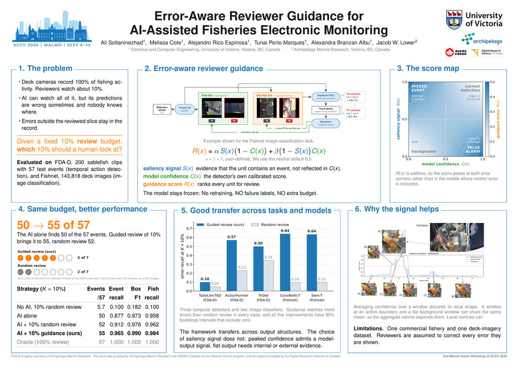
AI-assisted review of fisheries electronic-monitoring (EM) footage faces a fundamental resource constraint: modern detectors and classifiers can process all recorded data, but their predictions are imperfect, while human verification is limited by available reviewer time and is typically applied to only a small fraction of the footage. We propose error-aware reviewer guidance, a post-deployment procedure that takes a frozen (non-retrained) AI model and a fixed human review budget, combines the model’s confidence with a secondary saliency signal that captures information not reflected in that confidence, and prioritizes the predictions most likely to be incorrect for reviewer inspection. The procedure jointly targets potential false negatives, where saliency suggests the presence of an event despite low model confidence, and potential false positives, where the model is confident an event is present but the saliency signal provides little supporting evidence. We evaluate the approach on two fisheries EM tasks: temporal action detection (TAD) on FDA-D, a commercial sablefish trap-fishing video dataset, and detection-box (image) classification on Fishnet, a publicly available deck-camera imagery dataset aggregated from multiple commercial fisheries. At a 10% review budget (standard practice in fisheries), error-aware guidance substantially outperforms human random review (no AI involved), the current operational baseline, as well as a standalone AI model or a combination of AI with random human review. Cross-detector and per-feature analyses illustrate that the secondary signal source captures information not reflected in the AI model’s confidence estimates and complements it, enabling a more effective identification of likely errors. These results demonstrate that directing limited reviewer effort towards likely errors can substantially improve fisheries EM outcomes without retraining deployed AI systems, collecting failure labels, or increasing review budgets.
Short-Dwell Aerial Wave Sensing over Coastal Waters: Feasibility, Observability, and Failure Modes
James Theal Stewart, John S. Zelek
Abstract
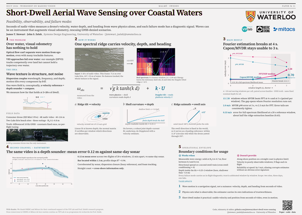
When aerial drones fly over feature-poor, dynamic surfaces, conventional visual odometry fails and localization is challenging, open water being representative. However, ocean waves obey physical laws like the dispersion relation, providing analyzable structure. Wavenumber, intrinsic frequency, and water depth couple, while Doppler mechanics allow observed frequency to constrain observer motion. We ask what can be measured from seconds of nadir video, at what accuracy, and with which failure modes, measuring offline against ground truth.
The dispersion relation defines a shell of admissible frequencies over wavenumber space. With depth supplied, the Doppler-shifted ridge constrains velocity, while the resulting normal matrix describes directional observability. Shell curvature estimates depth, and the swell axis provides a world-fixed reference. Across field windows, Fourier estimators show a resolution break between 6 and 4s, while Capon/MVDR degrades gracefully to 3s, with median errors 0.49m/s at 6s and 0.70m/s at 3s and lower p90. Likelihood-surface accumulation recovers two of three calm-sea crawls below the per-window estimator floor.
Quasi-static windows yield depth profiles supported by five consistency checks and a sonar survey confirming their shape. Assuming σd = 0.3m, these imply a 10-25m cross-shore localization scale where the profile carries enough information. Failure regimes such as a calm-seas observability threshold between Hs ≈ 0.2–0.6 m, speed aliasing at 5m/s, and deep-water saturation each show an in-flight diagnostic, establishing wave sensing as a measurable, self-diagnosing navigation channel for GNSS-denied aerial localization over water.
CoastalAnySat: Learning Robustness to Marine Atmospheric Correction
Ayush Prasad, Stefan Oehmcke
Abstract
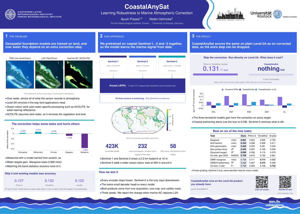
Geospatial foundation models are increasingly used as standard tools for Earth observation tasks, but their robustness to atmospheric- processing choices in coastal and marine settings remains underexplored. We compare aligned Sentinel-2 inputs processed with Sen2Cor Level- 2A and ACOLITE marine atmospheric correction (marine-AC) across ocean-state, bathymetry, oil-slick, seagrass, and mangrove tasks. Exist- ing foundation models gain an average of 0.131 in R^2 from marine-AC on ocean-state prediction, while vegetation-dominated tasks degrade. We introduce CoastalAnySat, an AnySat variant pretrained on 423,000 co- located Sentinel-1, Sentinel-2, and Sentinel-3 coastal observations. On ocean-state tasks, using only Sentinel-2 downstream, CoastalAnySat per- forms marginally better with Level-2A than marine-AC, with a mean change of -0.019 in R^2 , while remaining competitive across the bench- mark. An ablation shows that coastal pretraining reduces the benefit of marine-AC and that Sentinel-3 context substantially contributes to the observed robustness. Coastal multisensor pretraining can therefore reduce reliance on an additional marine atmospheric-correction pipeline at inference time. Code is available at https://github.com/ayushprd/CoastalAnySat.
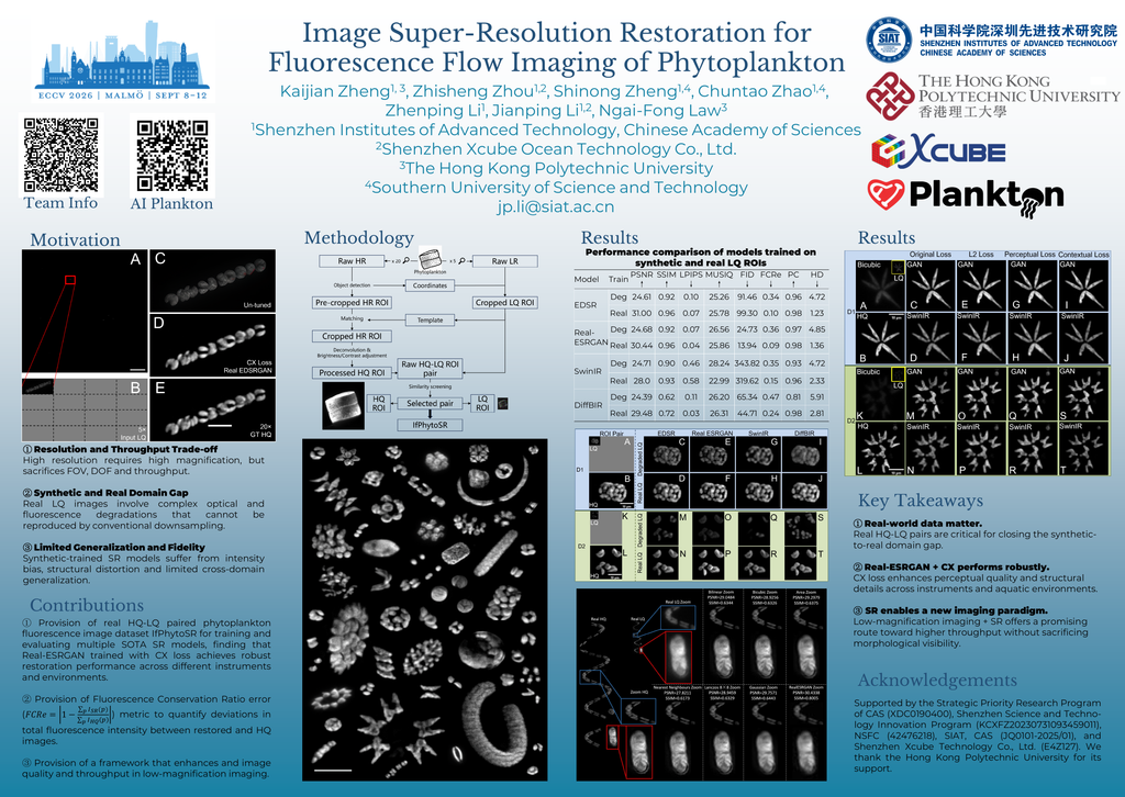
Image Super-Resolution Restoration for Fluorescence Flow Imaging of Phytoplankton
Kaijian Zheng, Zhisheng Zhou, Shinong Zheng, Chuntao Zhao, Zhenping Li, Jianping Li, Ngai-Fong Law
Abstract
Flow imaging has emerged as a promising technique for automated in situ observation of phytoplankton in natural waters. To resolve fine morpho-logical details of phytoplankton, existing instruments typically employ high-magnification optics, which inevitably restrict the field-of-view (FOV) and depth-of-field (DOF), thereby limiting analysis throughput. Although using low-magnification optics can expand the sampling volume by offering a larger FOV and DOF, it often compromises image resolution and quality. Deep learning-based image super-resolution restoration (SR) offers a promising solution to this resolution and throughput trade-off. However, the scarcity of real-world high-quality (HQ) and low-quality (LQ) image pairs has hindered the effective training of such models for practical deployment. In this work, we introduce IfPhytoSR, a real image dataset comprising 70,566 pairs of HQ-LQ fluorescence images captured from flowing phytoplankton. Using this dataset, we trained and compared four state-of-the-art SR models: EDSR, Real-ESRGAN, SwinIR, and DiffBIR. Extensive experimental results demonstrate that training with real data significantly enhances the SR performance and generalizability of all four models, facilitating broader adaptability across diverse instruments and aquatic environments. Although vali-dated on phytoplankton fluorescence images, the proposed synchronized du-al magnification imaging strategy is readily applicable to other fluorescence imaging modalities, such as cellular imaging, tissue imaging, and fluorescence-guided biomedical observation.
Quantifying the Resilience of Acoustic-Optical Fusion Under Physically-Informed Marine Optical Degradation
Tom Morgan, John E Halpin, Thomas A. Wilding
Abstract
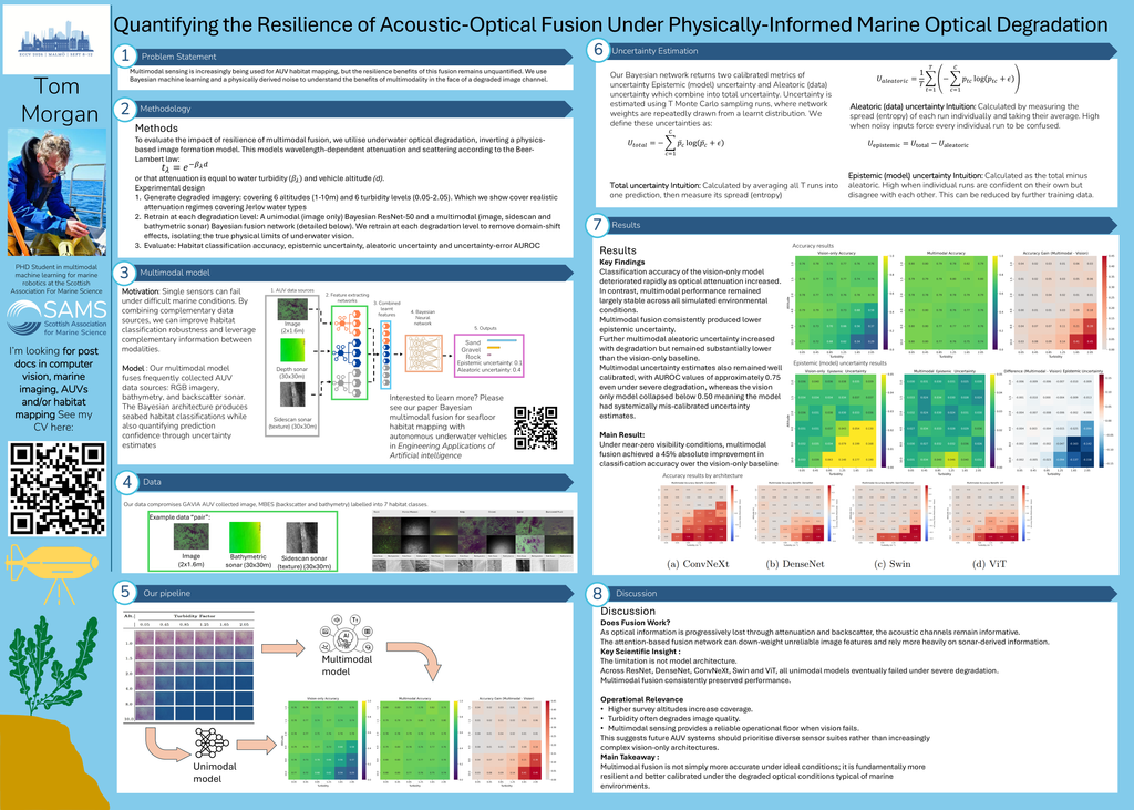
The primary challenge of marine perception lies in the degradation of the optical channel which can render vision-only systems unreliable. Acoustic sensors remain largely unaffected by these phenomena, meaning their fusion with image data offers a viable alternative. Despite this, the resilience benefits of multimodality remain unquantified in the marine domain. We investigate the resilience of multimodal marine sensing over unimodal vision sensing by simulating realistic underwater optical degradation utilising a physics-informed approach to assess the impact on habitat classification. Further, in order to isolate the inherent physical limitations from the optical channel from simple domain-shift, we retrain our unimodal and multimodal architectures independently at each level of degradation. We find that while unimodal vision-only performance collapses from 76% to 29% as image degradation increases, whereas multimodal accuracy declines only modestly from 80% to 76%. Furthermore, an analysis of Bayesian neural network uncertainties indicates that multimodal models maintain significantly lower uncertainties with a higher AUROC, demonstrating that fusion ensures more reliable, better-calibrated uncertainty metrics. These findings establish a foundation for resilient perception in high-attenuation regimes, demonstrating the benefit of multimodality across all domains of marine imaging including object detection and segmentation; habitat mapping, and autonomous underwater navigation.
Models trained on DebrisVision show significant performance gains. When trained on the combined dataset of synthetic and real images, YOLOv8 achieves a 2.29 times increase in detection mAP50 and a 3.03 times increase in segmentation mAP50; and YOLO11 achieves a 2.01 times increase in detection mAP50 and a 2.62 times increase in segmentation mAP50. DebrisVision also reduces the synthetic-to-real domain gap by 20%, enhancing performance in turbid conditions. By open-sourcing DebrisVision, we equip researchers and engineers with a scalable and diverse dataset to enhance autonomous marine cleanup, robotic navigation, and ecological monitoring. This initiative ultimately contributes to global efforts to combat ocean pollution.
CoralTexture: A Fine-Grained Benchmark for Species-Level Coral Recognition
Changen Yang, Wei Zhang, Chenchen Ge, Ahmed Elazab, Liang Xi, Shijin Wang, Qiyi Xu, Mengni Lei, Zhi Zhou, Zhuhua Hu, Jian Luo, TangKai, Zongxiu Wu
Abstract
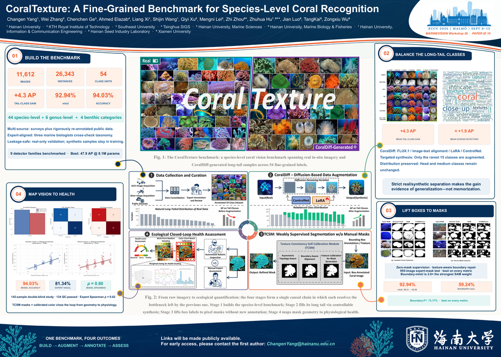
As coral reef ecosystems degrade, efficient computer vision-based monitoring has become essential for ecological conservation.However, research is hindered by the scarcity of fine-grained species-level data, extreme long-tail effects in natural distributions, and the high cost of pixel-level annotations in dense prediction tasks. To address these challenges, we present CoralTexture, the first large-scale species-level coral vision benchmark focused on high-fidelity texture, containing 11,612 images, 26,343 instances, and 54 precise classification units, and we tackle its natural long-tail distribution with a controllable diffusion pipeline. At its core, a controllable diffusion pipeline, CoralDiff, augments only the rarest species: guided by high-precision expert image–text alignment, it concentrates the synthetic gains on the long tail—improving tail-class detection by a mean of +4.3 AP—while leaving head and medium classes unaffected, thereby rebalancing the distribution without distorting the real evaluation data. Building on the enriched benchmark, we further demonstrate two lightweight downstream tasks that together close an ecological loop from recognition to physiology: a Texture Consistency Self-Calibration Module (TCSM) lifts species-level box priors to pixel masks under zero-mask pretraining, improving mIoU from 88.41% to 92.94%, and a color-calibrated health assessment module quantifies coral condition at 94.03% accuracy versus 81.34% for expert visual inspection. Beyond filling the gap in species-level fine-grained coral vision benchmarks, CoralTexture introduces a scalable, generation-driven paradigm for benthic ecological benchmarking. The code and dataset will be open-sourced upon acceptance.
Searching for Submarine O13: A Two-Step Classification and Similarity-Ranking Model for Submarine Identification in Sonar Imagery.
Fleur Bouwman, Erkut Akdag, Leon Hartenberg, Ulf Johannsen, Egor Bondarau
Abstract
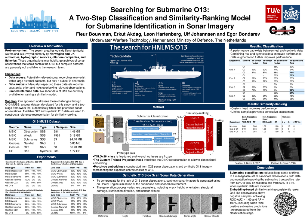
Submarine O13 of the Royal Netherlands Navy disappeared during World War II and has not been located since. Previous attempts to locate O13 have relied on externally collected sonar data, where limited data access has constrained the search. In this study, a two-stage framework is investigated, consisting of a submarine classification model followed by a similarity-ranking model designed to prioritize observations that are most consistent with the characteristics of the O13. The effects of data augmentation, synthetically generated samples, and different class configurations are systematically evaluated. The results show that data augmentation improves classification performance, increasing the true positive rate from 56% to 68%. When synthetic training data are included, the true positive rate further increases from 63% to 81%. The similarity-ranking model achieves an ROC-AUC of 1.0 and an average precision (AP) of 100% across all test-set configurations. These findings demonstrate that computer vision-based methods can support the identification and prioritization of relevant sonar observations, enabling efficient identification of specific vessels in large-scale sonar datasets.
WhaleTrack: Telemetry-Driven Georeferenced Multi-Whale Tracking from Drone Video
Pierre Adorni, Lucie Laporte-Devylder, Matthieu Le Lain, Thomas Fillon, Louis François–Downey, Kshitij Raj Sharma, Shivam Pande, Manuel Nkegoum, Sergio Suzerain Osson, Emanuel Goulart Farias, Frédéric Raimbault, Charlotte Pelletier, Marc CHAUMONT, Sébastien Lefèvre
Abstract
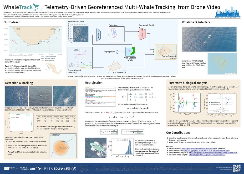
Competitive interactions among cetaceans require fine-scale spatial information to quantify relative movement, spacing, and changes in group structure. Drone-based studies offer detailed observations, but most automated pipelines return trajectories only in image coordinates. We present WhaleTrack, a modular system that combines oriented-bounding-box detection, multi-object tracking with lightweight spatial re-linking, telemetry-driven ray-plane reprojection from drone GPS, altitude, and gimbal orientation, and per-frame field-of-view estimation. Applied to competitive groups of humpback whales (Megaptera novaeangliae) from Los Cabos, Mexico, the detector reaches 94.7% mAP50 on 43 images from a held-out flight. A scale validation against a 7.3-m reference vessel yields a mean signed length error of −0.44 m over 1,431 estimates. We further illustrate how the resulting trajectories can support downstream group-position and relative body-size analyses across five annotated flights. WhaleTrack outputs georeferenced trajectories together with the instantaneous observation footprint, providing the context needed to interpret non-detections in moving-camera data. We release the annotated dataset, trained object detection model weights, and full pipeline to support reproducible drone-based marine-mammal monitoring.
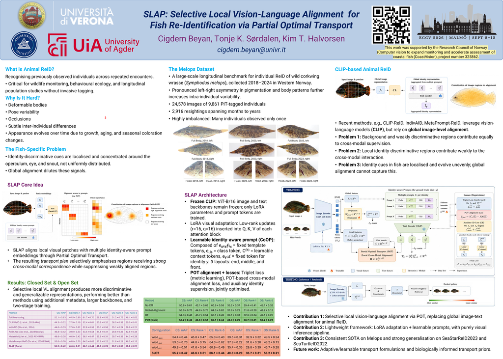
SLAP: Selective Local Vision-Language Alignment for Fish Re-Identification via Partial Optimal Transport
Cigdem Beyan, Tonje Knutsen Sørdalen, Kim Tallaksen Halvorsen
Abstract
Individual fish re-identification (ReID) is a fine-grained recognition problem in which identity-discriminative cues are often localized to specific body regions rather than distributed uniformly across the animal. Nevertheless, recent CLIP-based ReID methods rely predominantly on global image-text alignment, allowing background and weakly discriminative regions to contribute to cross-modal supervision. We propose a selective local vision-language alignment framework that establishes localized correspondences between visual patch embeddings and multiple identity-aware prompt embeddings through Partial Optimal Transport (POT). Rather than enforcing exhaustive correspondence, POT enables selective matching between visual patches and prompt embeddings, allowing the model to emphasize the strongest cross-modal correspondences while avoiding forced alignment of weakly matching regions, thereby yielding more discriminative visual representations for retrieval. The framework is trained end-to-end, while only the adapted visual encoder is retained during inference. Experiments on the longitudinal Symphodus melops dataset demonstrate consistent improvements over recent CLIP-based ReID methods under both closed-set and open-set evaluation protocols. Additional evaluations on other datasets further demonstrate the generalization capability of the proposed method across diverse marine ReID benchmarks.
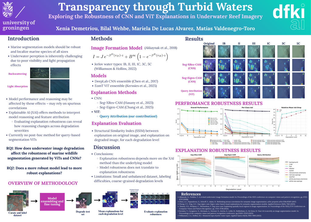
Transparency through Turbid Waters: Exploring the Robustness of CNN and ViT Explanations in Underwater Reef Imagery
Xenia Demetriou, Bilal Wehbe, Mariela De Lucas Alvarez, Matias Valdenegro-Toro
Abstract
Computer vision models are increasingly used for underwater inspection tasks, one of them being ecosystem restoration, but learning robust features is challenging in natural underwater scenes due to backscattering and light absorption causing turbidity and light attenuation. This degrades the underwater images, and may impact how the models reason and perform. Explainable AI (XAI) can reveal how image degradation affects model reasoning. This study evaluates the robustness of explanations from Convolutional Neural Networks (CNNs) and Vision Transformers (ViTs) for marine animal semantic segmentation under underwater image degradation. Images or marine reefs were annotated and used to fine-tune CNN and ViT ensembles for marine wildlife segmentation. Explanation heatmaps for each ensemble were generated for images of various levels of degradation, and their robustness were assessed using the Structural Similarity Index (SSIM) with respect to the original image’s explanation. One XAI method used is a newly proposed method for explaining query-based segmentation ViTs. Results show no clear difference in explanation robustness between CNNs and ViTs, however that explanation robustness is XAI method-specific. Furthermore, higher model robustness does not always guarantee more robust explanations.
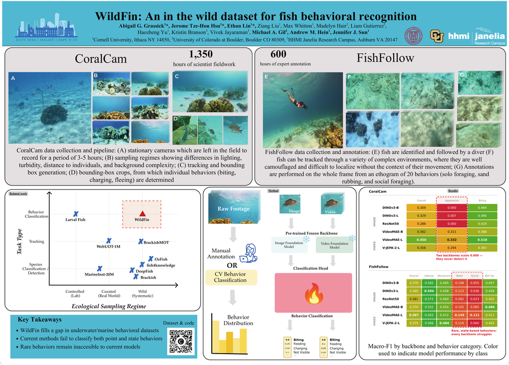
WildFin: An In-the-Wild Video Dataset for Fish Behavioral Recognition
Abigail Grassick, Jerome Tze-Hou Hsu, Ethan Lin, Ziang Liu, Max Whitton, Madelyn Hair, Liam Gutierrez, Haozheng Yu, Kristin Branson, Vivek Jayaraman, Michael A. Gil, Andrew M. Hein, Jennifer J. Sun
Abstract
Recent advances in field technology have led to a massive influx of in-the-wild video data for ecological science. The primary bottleneck in leveraging this data is the high cost of expert annotation. While computer vision offers a potential solution, current models frequently fail when deployed in complex marine environments. To characterize these failures, we introduce WildFin, a novel benchmark for fish behavior recognition collected and annotated by ecologists. WildFin spans two critical real-world paradigms: stationary cameras monitoring groups of fish and dynamic divers following individual subjects. The dataset represents a massive curation effort, involving 1,350 hours of fieldwork and 600 hours of expert annotation to produce 9 hours of behavioral data with over 2 million frame-by-frame labels. We benchmark modern vision foundation models and quantify tradeoffs between static and spatiotemporal architectures, revealing the substantial gap that remains between current model capabilities and the demands of real-world underwater behavioral analysis. Project website: https://team-wildfin.github.io.
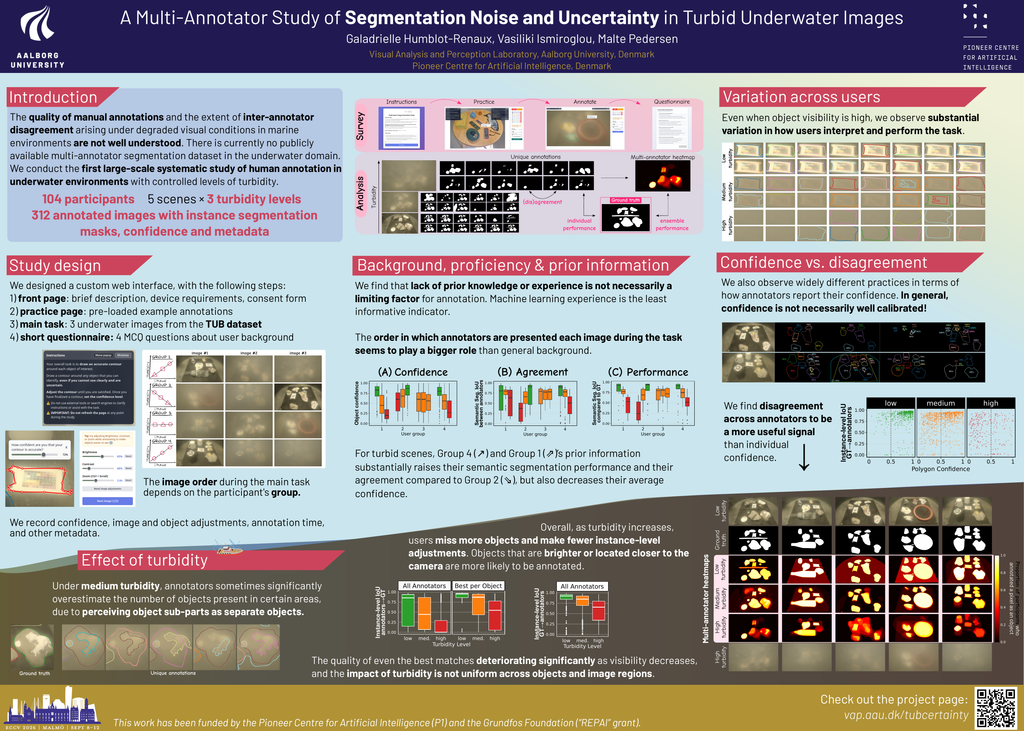
A Multi-Annotator Study of Segmentation Noise and Uncertainty in Turbid Underwater Images
Galadrielle Humblot-Renaux, Vasiliki Ismiroglou, Malte Pedersen
Abstract
Label uncertainty and annotator disagreement are common challenges in the field of computer vision, yet their study has largely been confined to the medical domain or to generic image-recognition datasets. Underwater datasets are particularly susceptible to these issues due to the need for domain expertise, degraded visibility conditions, and the inherent difficulty of establishing reliable ground truth in inaccessible environments. Despite these challenges, annotation uncertainty in underwater imagery remains largely unexplored. In this work, we present the first systematic multi-annotator study of segmentation in real underwater scenes, with over 100 participants, and across varying, controlled levels of turbidity. We show that underwater datasets face many of the same annotation challenges as other vision tasks, while turbidity introduces additional systematic errors. We further investigate the main factors driving label noise and explore ways to improve annotation quality in turbid underwater environments, including privileged information, individual effort and annotator ensembles. All (meta-) data collected in this study will be available on the project page: https://vap.aau.dk/tubcertainty
PatchMatch: Cross-Sensor Matching of Marine Litter Patches in Satellite Double Acquisitions
Gabrielė Tijūnaitytė, Emanuele Dalsasso, Marc Rußwurm
Abstract
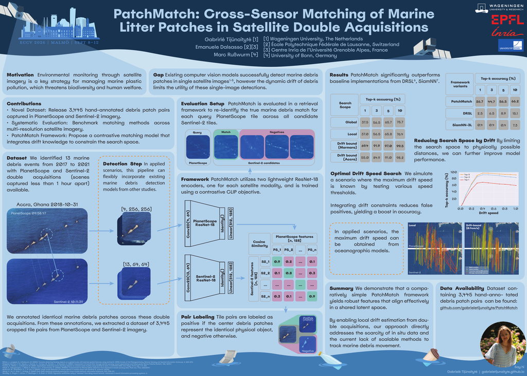
In open waters, marine litter agglomerated with natural debris often forms large patches that are visible in satellite imagery. While existing computer vision models successfully detect these debris patches in single satellite images, the dynamic drift of debris due to winds and currents limits the utility of these single-image detections. Matching debris patches across two different satellite images acquired on the same day is essential to unlock temporal tracking of marine litter, but remains an open scientific challenge. This paper presents PatchMatch, a CLIP-based matching approach that re-identifies debris patches across two satellite image modalities of different spectral bands and resolutions. We show that the proposed framework achieves a Top-1 retrieval accuracy of 37.5% and a Top-3 accuracy of 56.6% in a large search space, significantly outperforming baseline models. This performance improves substantially to a Top-1 accuracy of 62.2% and the Top-3 accuracy of 88.4% when restricting the search space using drift knowledge. We release the open-source pre-trained PatchMatch alongside our extensively annotated training and validation datasets to lay the foundation for further research towards automated, time-aware monitoring of marine plastic transport.
BenthicFlow: Generating Extensible Underwater Environments via Flow Matching
Joaquín Figueira, Camile Lendering, Manfred Gonzalez-Hernandez, Giacomo D’Amicantonio, Erkut Akdag, Egor Bondarau
Abstract
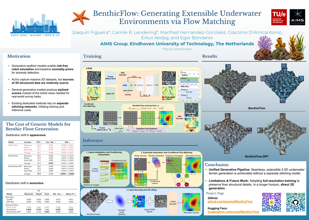
Computer vision applications for 3D scene understanding in underwater environments remain challenging due to the lack of high-quality 3D data and the inability of surface-trained models to generalize to underwater scenes. To address this challenge, an emerging trend is to employ generative models to close the data domain gap. However, existing methods assemble large scenes by stitching independently generated tiles post hoc with separately trained models, while demonstrating heterogeneous landscapes only within individual survey sites. We introduce BenthicFlow, a unified framework based on a single conditional flow-matching model that jointly generates aligned textures and depth maps. A MultiDiffusion-inspired sampling procedure reconciles overlapping windows throughout the generative trajectory, enabling spatially extensible RGBD mosaics without a separate stitching model. The generated mosaics are subsequently lifted into explicit 3D benthic environments using surface-aligned Gaussian surfels. Experiments across geographically distinct survey sites demonstrate that BenthicFlow preserves site-specific appearance while generating coherent, large-scale 3D scenes that closely match the target distributions. Code and trained models are available at https://github.com/jacomof/BenthicFlow.
AQUABENCH: Evaluating Vision Foundation Models for Underwater Segmentation
Torben Globisch, Stefan Oehmcke
Abstract
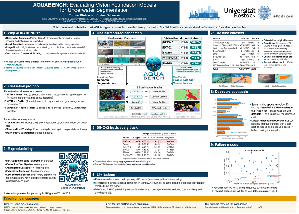
Underwater computer vision underpins environmental monitoring, marine robotics, and infrastructure inspection, yet how well modern vision foundation models (VFMs) transfer to underwater imagery remains poorly characterized. Progress is limited by the absence of a standardized framework that isolates representation quality under underwater domain shifts induced by light attenuation, scattering, and wavelength-dependent color distortion. We introduce AQUABENCH, a unified semantic segmentation benchmark that repurposes and transforms nine publicly available underwater datasets while preserving their original class taxonomy and enforcing a consistent evaluation protocol. We evaluate frozen encoders using token-matched linear probing and a frozen-encoder UPerNet decoder, with a fully fine-tuned ResNet-50 as a supervised reference. Across five VFM families, DINOv3 achieves the strongest aggregate rank in all three evaluation tracks. However, dataset-level rankings vary, larger encoders do not consistently improve transfer, and decoder capacity substantially affects performance. AQUABENCH provides a reproducible testbed for studying pretrained representation transfer to underwater semantic segmentation.
CoralscapesV2: Panoptic and Fine-Grained Visual Scene Understanding in Coral Reefs
Jonathan Sauder, Thomas Ruckli, Gabrielė Strodomskytė, Djama Goumaneh Awaleh, Mohamed Houssein Farah, Ibrahim Souleiman Abdallah, Rahma Hassan Abdi, Devis Tuia, Guilhem Banc-Prandi
Abstract
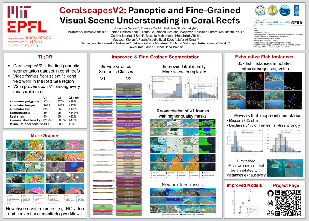
In order to design conservation and restoration strategies to counter the global decline of coral reefs, ecological monitoring of reefs needs to be scaled up dramatically. Computer vision methods are increasingly used to tackle the vast amount of data: as the paradigm of data collection in reefs shifts from highly standardized and constrained survey images to unconstrained imagery on scalable platforms, it is necessary to design machine learning methods that help to get a fine-grained understanding of reefs from general-purpose reef imagery. This paper provides CoralscapesV2, an extension of the Coralscapes dataset for general-purpose visual scene understanding in reefs. CoralscapesV2 increases the dataset size, scope, label completeness and quality for semantic segmentation, and extends the number of classes from 39 to 95 fine-grained visual categories. Furthermore, CoralscapesV2 provides 65k exhaustive fish instance mask annotations, meticulously annotated to completeness by using the video, revealing that annotation of fish based on only static images is insufficient. CoralscapesV2 is the first dataset for panoptic segmentation in coral reefs, capturing a wide range of scenarios in the wild, posing a challenging benchmark for contemporary semantic segmentation and instance segmentation models. CoralscapesV2 is an important step towards general-purpose panoptic segmentation in coral reefs, which has substantial implications for scaling up coral reef monitoring, as it can be employed in a wide range of applications from benthic cover mapping from robot or handheld videos to designing methods for automated quantification and understanding of fish behavior and fish-reef interactions.
MarineMamba: Multi-Granularity CLIP Feature Integration with Dual Mamba for Underwater Classification
Alireza Hoseinzade, Mostafa Shahbazi Dil, Mohammad Mahmoudabadi, Mansoor Rezghi
Abstract
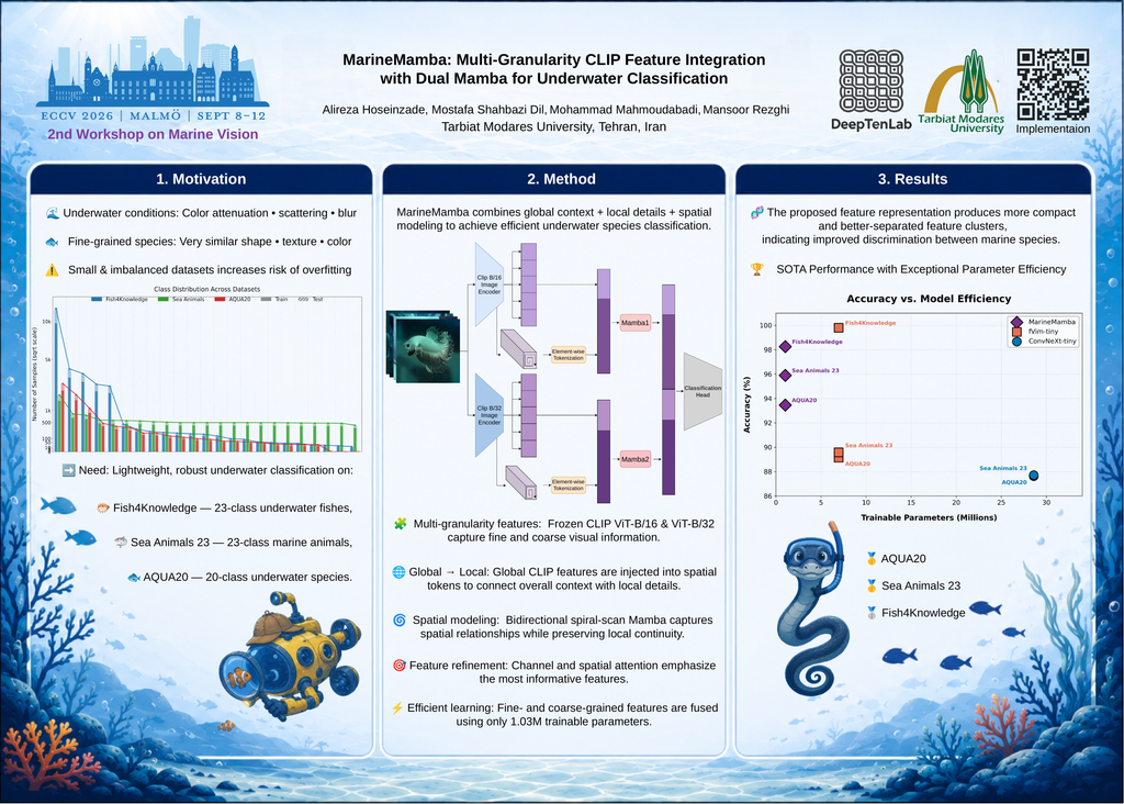
Recognizing marine and aquatic species in underwater imagery is a fine-grained problem: species differ by subtle shape, fin, and texture cues, while images suffer from wavelength-dependent attenuation, scattering, and non-uniform illumination. Fully fine-tuning large CNN, Transformer, or state-space backbones on small, long-tailed collections can therefore be brittle. We propose MarineMamba, a parameter-efficient classifier that keeps CLIP ViT-B/16 and ViT-B/32 frozen and trains only a compact dual-branch state-space head. Each branch projects the corresponding spatial grid, injects the global CLIP feature vector into the token sequence, scans patches in a locality-preserving bidirectional spiral order with a shared Mamba layer, and applies channel-and-spatial attention before fine and coarse descriptors are fused. Under the same training protocol, a fine-tuned ImageNet-pretrained Vim-tiny baseline obtains 89.14%, 89.58%, and 99.80% top-1 accuracy on AQUA20, Sea Animals 23, and Fish4Knowledge, respectively; MarineMamba reaches 93.46%, 95.90%, and 98.25% with 1.03M trainable parameters versus 6.96M. Ablations show that removing Mamba or feature-vector injection reduces AQUA20 accuracy by 7.46 and 8.37 points, identifying global-to-spatial propagation as the central mechanism. Overall, MarineMamba provides parameter-efficient adaptation for underwater recognition without full backbone fine-tuning. Our implementation is available at https://github.com/alirezahos78/MarineMamba.git.
IsPlanktonMD: Physics-Guided Motion Deblurring for In situ Darkfield Plankton Imaging
Yao Min, Li Zhenping, Wang Boxue, Jianping Li
Abstract
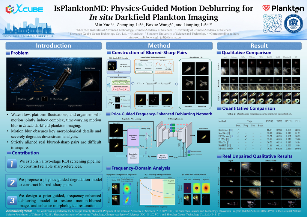
In situ darkfield plankton imaging is susceptible to complex, time-varying motion blur induced by water flow, platform fluctuations, and organism self-motion, which obscures morphological structures important for downstream analysis. Restoring such images is challenging because the degradation is complex and strictly aligned blurred–sharp pairs of the same target are difficult to acquire under real imaging conditions. To address these challenges, we propose IsPlanktonMD, a physics-guided framework that constructs reliable paired supervision through high-quality ROI screening and exposure-trajectory-based blur synthesis, and restores blurred images using a prior-conditioned, frequency-enhanced network. The network estimates degradation information from blurred inputs and incorporates skip-feature reweighting, frequency domain modeling, and perceptual regularization to improve morphological restoration. Experiments show that IsPlanktonMD achieves the best SSIM, LPIPS, and FID on the synthetic paired test set while remaining within 0.26 dB of the best PSNR. Qualitative results on real motion-blurred images further show reduced motion trailing and improved preservation of local structures, demonstrating its potential to support more reliable downstream plankton analysis.